किपा:Island of Ireland location map Dublin.svg

Size of this PNG preview of this SVG file: ४८१ × ५९९ pixels. Other resolutions: १९२ × २४० pixels | ३८५ × ४८० pixels | ६१६ × ७६८ pixels | ८२२ × १,०२४ pixels | १,६४३ × २,०४८ pixels | १,४५० × १,८०७ pixels.
Original file (SVG file, nominally १,४५० × १,८०७ pixels, file size: ६४२ KB)
| Description |
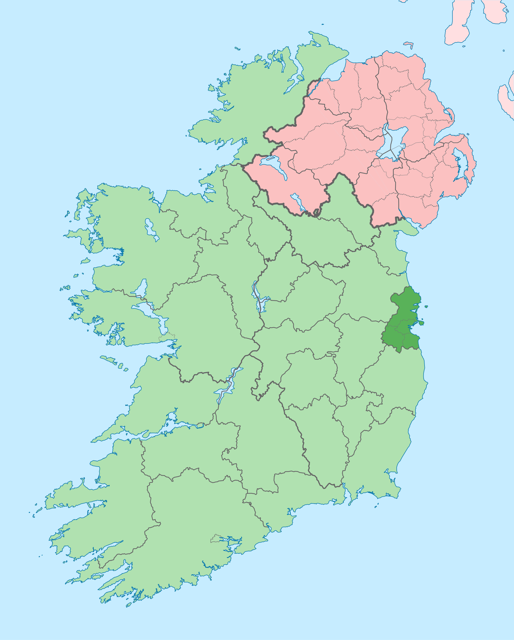
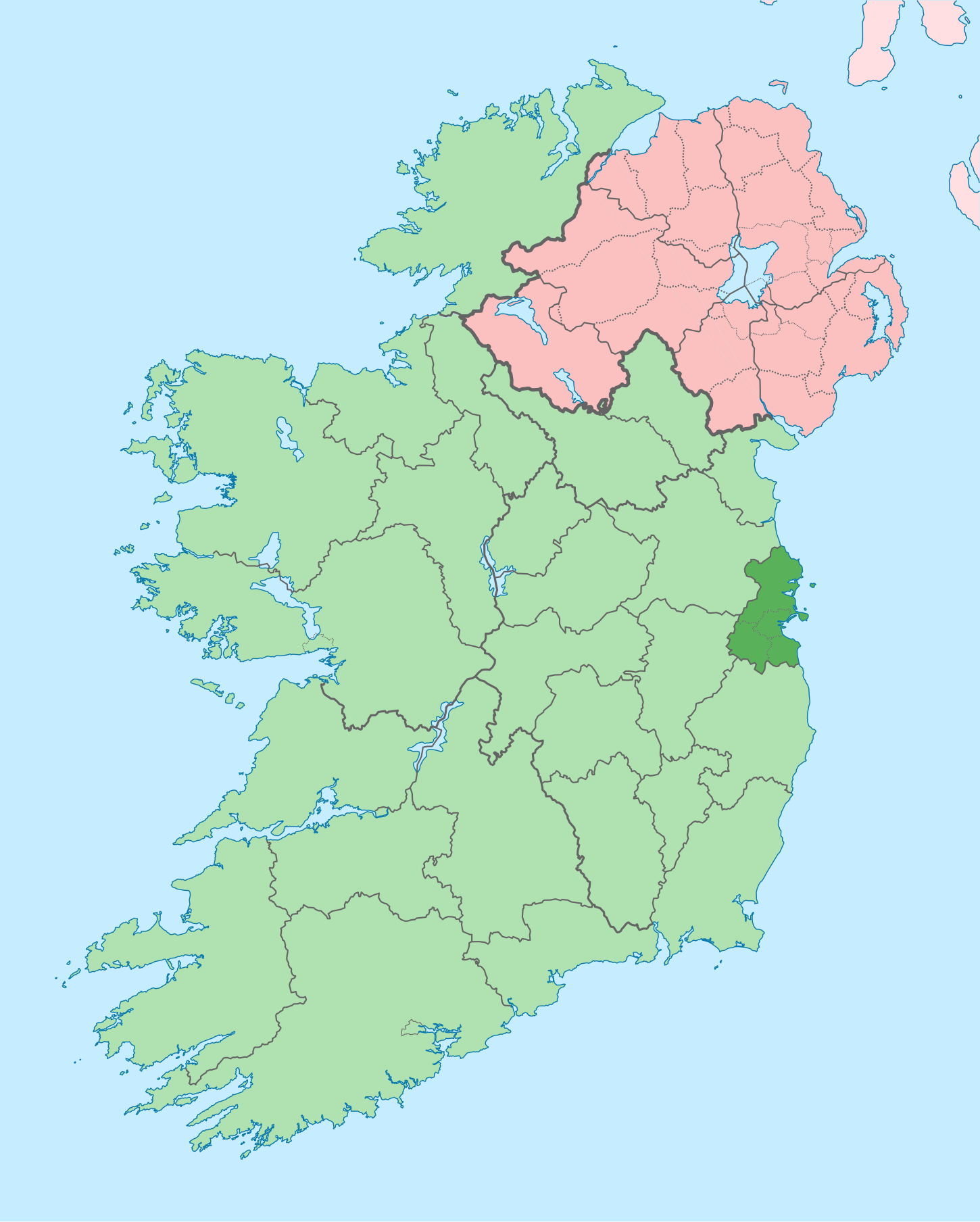
English: The island of Ireland, showing international border between Ireland and Northern Ireland, traditional provinces, traditional counties, and local authority areas in Ireland and Northern Ireland. |
| Date | (UTC) |
| Source | |
| Author |
|
| Other versions |
Derivative works of this file: |
| This is a retouched picture, which means that it has been digitally altered from its original version. Modifications: Coloured in regions with county of article highlighted. The original can be viewed here: Island of Ireland location map.svg:
|
I, the copyright holder of this work, hereby publish it under the following license:
This file is licensed under the Creative Commons Attribution-Share Alike 3.0 Unported license.
- You are free:
- to share – to copy, distribute and transmit the work
- to remix – to adapt the work
- Under the following conditions:
- attribution – You must give appropriate credit, provide a link to the license, and indicate if changes were made. You may do so in any reasonable manner, but not in any way that suggests the licensor endorses you or your use.
- share alike – If you remix, transform, or build upon the material, you must distribute your contributions under the same or compatible license as the original.
Original upload log
This image is a derivative work of the following images:
- File:Island_of_Ireland_location_map.svg licensed with Cc-by-sa-3.0
- 2010-03-06T20:43:33Z Rannpháirtí anaithnid 1450x1807 (679207 Bytes) Fix incorrectly coloured isands.
- 2010-03-03T22:19:29Z Rannpháirtí anaithnid 1450x1807 (679744 Bytes) {{Information |Description={{de|Positionskarte von [[:de:Irland|Irland]]}} Quadratische Plattkarte, N-S-Streckung 170 %. Geographische Begrenzung der Karte: * N: 55.6° N * S: 51.2° N * W: 11.0° W * O: 5.0° W {{en|Location
Uploaded with derivativeFX
File history
Click on a date/time to view the file as it appeared at that time.
| Date/Time | Thumbnail | Dimensions | छ्य्लामि | Comment | |
|---|---|---|---|---|---|
| current | ०९:१६, ३ जुलाई २०२० | | १,४५० × १,८०७ (६४२ KB) | Chipmunkdavis | Per the Local Government Reform Act 2014, joining both Tipperarys and both Waterfords (and removing Limerick City code). Colouring in islands, cleaning up and grouping code to remove stray objects and show Galway and Lough Ree. |
| ००:४४, १९ जुलाई २०१० |  | १,४५० × १,८०७ (८१५ KB) | Mabuska | {{Information |Description={{en|The island of Ireland, showing international border between Northern Ireland and Republic of Ireland, traditional provinces, traditional counties, and local authority areas in the Republic of Ireland and Northern Ireland.}} |
File usage
There are no pages that use this file.
Global file usage
The following other wikis use this file:
- Usage on ar.wikipedia.org
- Usage on ast.wikipedia.org
- Usage on bg.wikipedia.org
- Usage on ca.wikipedia.org
- Usage on cs.wikipedia.org
- Usage on da.wikipedia.org
- Usage on en.wikipedia.org
- County Dublin
- Dublin
- Swords, Dublin
- Sydney Parade Avenue
- Northside, Dublin
- Southside, Dublin
- Merrion Centre, Dublin
- List of Ireland-related topics
- South Dublin
- Dún Laoghaire–Rathdown
- Fingal
- Template:County Dublin
- Tallaght
- List of Dublin postal districts
- Shenick Island
- Park Avenue, Dublin
- Kilmore West
- Greater Dublin Area
- Nutgrove
- Sutton Park, Dublin
- Man of War, Fingal
- Template:Dublin-geo-stub
- Heytesbury Street
- N32 road (Ireland)
- History of Belfast
- List of subdivisions of County Dublin
- North Wall, Dublin
- Sutton Creek (Ireland)
- Glenview, Tallaght
- Shandon, Dublin
- Ashtown Castle
- Red Gap
View more global usage of this file.