किपा:Kerala-administrative-divisions-map-en.png
Size of this preview: ५४० × ६०० pixels. Other resolutions: २१६ × २४० pixels | ४३२ × ४८० pixels | ६९१ × ७६८ pixels | ९२२ × १,०२४ pixels | १,८४३ × २,०४८ pixels | २,७०० × ३,००० pixels.
Original file (२,७०० × ३,००० pixels, file size: ५९४ KB, MIME type: image/png)
Summary
| Description |
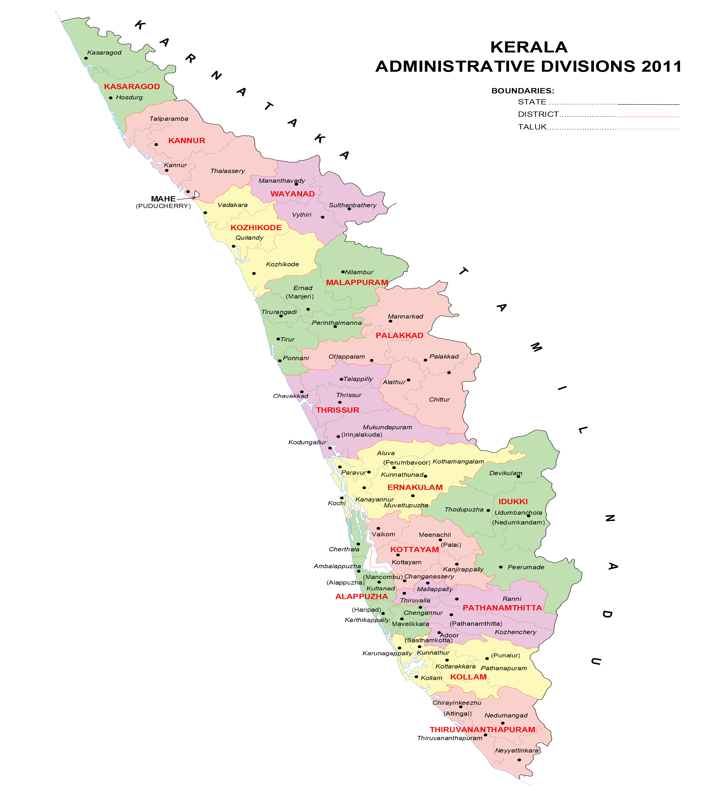
English: Kerala administrative divisions 2011, png version, English |
| Date | (UTC) |
| Source | Own work |
| Author | Rajeshodayanchal |

|
File:Kerala-administrative-divisions-map-en.svg is a vector version of this file. It should be used in place of this PNG file when not inferior.
File:Kerala-administrative-divisions-map-en.png → File:Kerala-administrative-divisions-map-en.svg
For more information, see Help:SVG. |
 |
Licensing
I, the copyright holder of this work, hereby publish it under the following license:
This file is licensed under the Creative Commons Attribution-Share Alike 3.0 Unported license.
- You are free:
- to share – to copy, distribute and transmit the work
- to remix – to adapt the work
- Under the following conditions:
- attribution – You must give appropriate credit, provide a link to the license, and indicate if changes were made. You may do so in any reasonable manner, but not in any way that suggests the licensor endorses you or your use.
- share alike – If you remix, transform, or build upon the material, you must distribute your contributions under the same or compatible license as the original.
File history
Click on a date/time to view the file as it appeared at that time.
| Date/Time | Thumbnail | Dimensions | छ्य्लामि | Comment | |
|---|---|---|---|---|---|
| current | ०६:३४, १० मे २०११ | | २,७०० × ३,००० (५९४ KB) | Rajeshodayanchal | Some small changes |
| ०८:५२, ९ मे २०११ |  | २,७०० × ३,००० (६०० KB) | Rajeshodayanchal | {{Information |Description ={{en|1=Kerala administrative divisions 2011, png version, English}} |Source ={{own}} |Author =Rajeshodayanchal |Date =~~~~~ |Permission = |other_versions = }} [[Catego |
File usage
The following page uses this file:
Global file usage
The following other wikis use this file:
- Usage on ur.wikipedia.org