किपा:Location Germany EU Europe.png

Size of this preview: ७१३ × ६०० pixels. Other resolutions: २८५ × २४० pixels | ५७१ × ४८० pixels | ९१३ × ७६८ pixels | १,२१८ × १,०२४ pixels | २,००० × १,६८२ pixels.
Original file (२,००० × १,६८२ pixels, file size: ५५५ KB, MIME type: image/png)
Summary
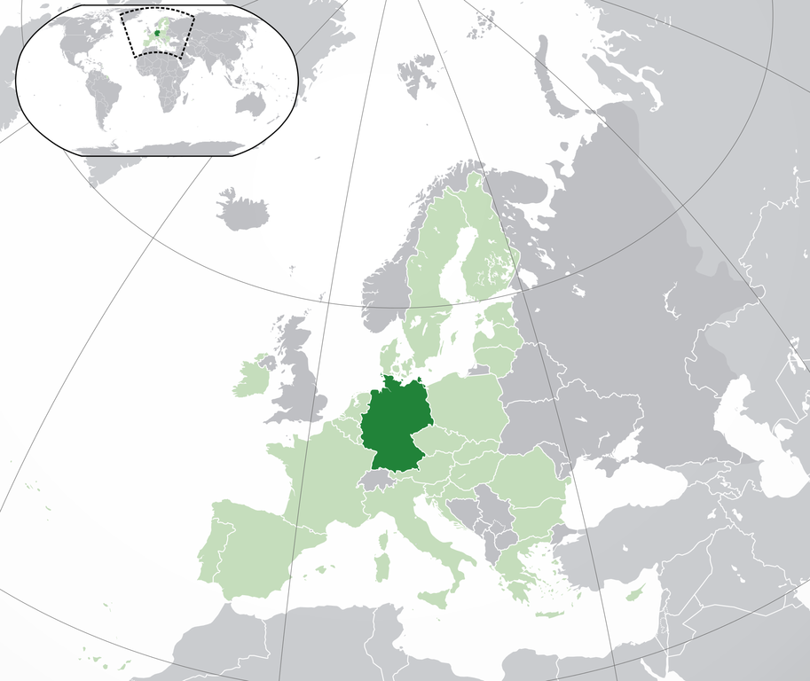
| Description | Location map: Germany (dark green) / European Union (light green) / Europe (dark grey); inspired by and consistent with general country locator maps by User:Vardion, et al. | |||
| Date | ||||
| Source | Own work | |||
| Author | Quizimodo | |||
| Other versions |
|


Licensing
| This work has been released into the public domain by its author, I, Quizimodo. This applies worldwide. In some countries this may not be legally possible; if so: I, Quizimodo grants anyone the right to use this work for any purpose, without any conditions, unless such conditions are required by law. |
File history
Click on a date/time to view the file as it appeared at that time.
| Date/Time | Thumbnail | Dimensions | छ्य्लामि | Comment | |
|---|---|---|---|---|---|
| current | १८:२३, २८ जुलाई २०२० | | २,००० × १,६८२ (५५५ KB) | Maphobbyist | Update: UK left the EU |
| १७:५१, १ अक्टोबर २०१४ |  | २,०५६ × १,७१० (३६४ KB) | Maphobbyist | Update: Croatia | |
| ०१:१५, १८ जुन २००७ |  | २,०५६ × १,७१० (१७५ KB) | Quizimodo~commonswiki | image (updated) | |
| ०९:३८, १७ जुन २००७ |  | २,०५६ × १,७१० (२२७ KB) | Quizimodo~commonswiki | image (tweaked) | |
| ०८:०९, १७ जुन २००७ |  | २,०५६ × १,७१० (२२६ KB) | Quizimodo~commonswiki | {{Information |Description=Location map: Germnay (dark green) / European Union (light green) / Europe (dark grey); inspired by and consistent with general country locator maps by User:Vardion, et al |Source=self-made |Date=17 June 2007 |Author= [[User:Qui |
File usage
The following page uses this file:
Global file usage
The following other wikis use this file:
- Usage on an.wikipedia.org
- Usage on ar.wikipedia.org
- Usage on ar.wikinews.org
- Usage on cs.wikipedia.org
- Usage on de.wiktionary.org
- Usage on en.wikipedia.org
- Usage on es.wikipedia.org
- Categoría:Baviera
- Categoría:Renania del Norte-Westfalia
- Categoría:Baden-Wurtemberg
- Categoría:Schleswig-Holstein
- Categoría:Sajonia
- Categoría:Renania-Palatinado
- Categoría:Mecklemburgo-Pomerania Occidental
- Categoría:Turingia
- Categoría:Sajonia-Anhalt
- Categoría:Hesse
- Categoría:Brandeburgo
- Categoría:Sarre
- Categoría:Baja Sajonia
- Categoría:Hamburgo
- Anexo:Embajadores de Honduras en Alemania
- Categoría:Bremen (estado)
- Usage on ga.wiktionary.org
- Usage on incubator.wikimedia.org
- Usage on ka.wikipedia.org
- Usage on krc.wikipedia.org
- Usage on lad.wikipedia.org
- Usage on myv.wikipedia.org
- Usage on pag.wikipedia.org
- Usage on pam.wikipedia.org
- Usage on qu.wikipedia.org
- Usage on ro.wikipedia.org
- Usage on ro.wikibooks.org
- Usage on ru.wikipedia.org
- Usage on scn.wikipedia.org
- Usage on sv.wikipedia.org
- Usage on uk.wikivoyage.org
- Usage on yi.wikipedia.org
View more global usage of this file.