किपा:Map Macedonia 336 BC-es.svg

Size of this PNG preview of this SVG file: ७४९ × ६०० pixels. Other resolutions: ३०० × २४० pixels | ६०० × ४८० pixels | ९६० × ७६८ pixels | १,२७९ × १,०२४ pixels | २,५५९ × २,०४८ pixels | ९९२ × ७९४ pixels.
Original file (SVG file, nominally ९९२ × ७९४ pixels, file size: ३.४१ MB)
| Description |
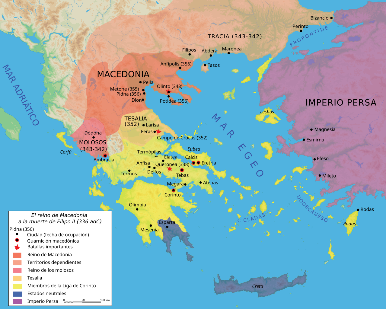
Español: Mapa del reino de Filipo II a su muerte, 336 adC |
||||||||
| Date | |||||||||
| Source |
Own work using Adobe Illustrator (data from R. Ginouvès and al., La Macédoine, Paris, 1992). Translated from Image:Map Macedonia 336 BC-fr.svg. |
||||||||
| Author | Marsyas; Kordas | ||||||||
| Permission (Reusing this file) |
I, the copyright holder of this work, hereby publish it under the following licenses:
This file is licensed under the Creative Commons Attribution-Share Alike 2.5 Generic license.
You may select the license of your choice. |
||||||||
| Other versions |
[]
|


|
This SVG file contains embedded text that can be translated into your language, using any capable SVG editor, text editor or the SVG Translate tool. For more information see: About translating SVG files. |
File history
Click on a date/time to view the file as it appeared at that time.
| Date/Time | Thumbnail | Dimensions | छ्य्लामि | Comment | |
|---|---|---|---|---|---|
| current | २२:२४, २७ जुन २००७ | | ९९२ × ७९४ (३.४१ MB) | Bibi Saint-Pol | fix several SVG problems; restore legend: this is part of the map |
| ०८:११, २० मार्च २०१७ |  | १,०५८ × ८४७ (४.०७ MB) | Rowanwindwhistler | https://en.wikipedia.org/wiki/Wikipedia:WikiProject_Maps/Conventions Fake text added | |
| ०७:३६, २५ फेब्रुवरी २०१६ |  | ९९२ × ७९४ (३.५९ MB) | Rowanwindwhistler | Cleaner version, height per layer for easier modification, duplication of islands removed. | |
| ०६:५६, २५ फेब्रुवरी २०१६ |  | ९९२ × ७९४ (३.०६ MB) | Rowanwindwhistler | Battle symbols on top | |
| ०९:२८, २२ फेब्रुवरी २०१६ |  | ९९२ × ७९४ (३.०६ MB) | Rowanwindwhistler | Eubea corrected | |
| १९:२०, २९ डिसेम्बर २०१५ |  | ९९२ × ७९४ (३.०६ MB) | Rowanwindwhistler | No transparency for the sea | |
| १९:१७, २९ डिसेम्बर २०१५ |  | ९९२ × ७९४ (३.०६ MB) | Rowanwindwhistler | Coast added, sea colour changed as per https://en.wikipedia.org/wiki/Wikipedia:WikiProject_Maps/Conventions | |
| २२:२९, २७ जुन २००७ |  | ९९२ × ७९४ (३.४१ MB) | Bibi Saint-Pol | {{Information |Description= {{es|Mapa del reino de Filipo II a su muerte, 336 adC}} Source=Own work using Adobe Illustrator (data from R. Ginouvès and al., ''La Macédoine'', Paris, 1992). Translated from [[:Image:Map Macedonia 336 | |
| २३:५४, १३ जुन २००७ |  | ९९३ × ७९४ (३.४३ MB) | Ignacio Icke | -legend off | |
| २३:२९, १२ जुन २००७ |  | ९९३ × ७९४ (३.४३ MB) | Ignacio Icke | trying to solve the rectangles thing |
File usage
There are no pages that use this file.
Global file usage
The following other wikis use this file:
- Usage on ast.wikipedia.org
- Usage on es.wikipedia.org
- Usage on eu.wikipedia.org
- Usage on gl.wikipedia.org
- Usage on hu.wikipedia.org
- Usage on la.wikipedia.org
- Usage on pl.wikipedia.org
- Usage on sq.wikipedia.org