किपा:Map of Florida highlighting St. Johns County.svg

Size of this PNG preview of this SVG file: ६०१ × ५९९ pixels. Other resolutions: २४१ × २४० pixels | ४८१ × ४८० pixels | ७७० × ७६८ pixels | १,०२७ × १,०२४ pixels | २,०५४ × २,०४८ pixels | ७,३४२ × ७,३२१ pixels.
Original file (SVG file, nominally ७,३४२ × ७,३२१ pixels, file size: ३१० KB)
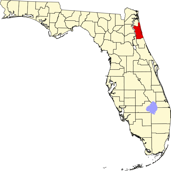
This is a locator map showing Saint Johns County in Florida.
David Benbennick made this map. For more information, see Commons:United States county locator maps.
| I, the copyright holder of this work, release this work into the public domain. This applies worldwide. In some countries this may not be legally possible; if so: I grant anyone the right to use this work for any purpose, without any conditions, unless such conditions are required by law. |
File history
Click on a date/time to view the file as it appeared at that time.
| Date/Time | Thumbnail | Dimensions | छ्य्लामि | Comment | |
|---|---|---|---|---|---|
| current | ०५:४३, १४ फेब्रुवरी २००६ | | ७,३४२ × ७,३२१ (३१० KB) | David Benbennick | New version with Lake Okeechobee |
| १०:५१, १२ फेब्रुवरी २००६ |  | ७,३४२ × ७,३२१ (३०७ KB) | David Benbennick | {{subst:User:Dbenbenn/clm|county=Saint Johns County|state=Florida}} |
File usage
The following page uses this file:
Global file usage
The following other wikis use this file:
- Usage on ar.wikipedia.org
- Usage on arz.wikipedia.org
- Usage on bg.wikipedia.org
- Usage on bpy.wikipedia.org
- Usage on cdo.wikipedia.org
- Usage on ceb.wikipedia.org
- Usage on ce.wikipedia.org
- Usage on cy.wikipedia.org
- Usage on de.wikipedia.org
- St. Johns County
- St. Augustine (Florida)
- Marineland (Florida)
- Vorlage:Navigationsleiste Orte im St. Johns County
- Hastings (Florida)
- St. Augustine Beach
- Butler Beach
- Crescent Beach (Florida)
- Flagler Estates
- Fruit Cove
- Nocatee
- Palm Valley (Florida)
- Sawgrass
- St. Augustine Shores
- St. Augustine South
- Vilano Beach
- World Golf Village
- Usage on en.wikipedia.org
- List of counties in Florida
- St. Johns County, Florida
- Marineland, Florida
- Butler Beach, Florida
- Crescent Beach, St. Johns County, Florida
- Fruit Cove, Florida
- Hastings, Florida
- Palm Valley, Florida
- Sawgrass, Florida
- St. Augustine, Florida
- St. Augustine Shores, Florida
- Vilano Beach, Florida
- St. Augustine Beach, Florida
- St. Augustine South, Florida
- Ponte Vedra Beach, Florida
- Template:St. Johns County, Florida
- Switzerland, Florida
- Julington Creek Plantation, Florida
- Elkton, Florida
- Armstrong, Florida
- Spuds, Florida
- Vermont Heights, Florida
- St. Johns, Florida
View more global usage of this file.