किपा:Scg01.png

Size of this preview: ४०९ × ६०० pixels. Other resolutions: १६३ × २४० pixels | ३२७ × ४८० pixels | ८१८ × १,२०० pixels.
Original file (८१८ × १,२०० pixels, file size: ५६ KB, MIME type: image/png)
Summary
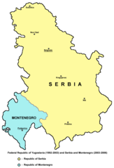
- English: Federal Republic of Yugoslavia (1992-2003) and Serbia and Montenegro (2003-2006).
- Serbian: Savezna Republika Jugoslavija (1992-2003) i Srbija i Crna Gora (2003-2006).
References
- Slobodan Radovanović, Geografski atlas, Magic Map, Smederevska Palanka, 2001.
- Školski geografski atlas, Intersistem Kartografija, Beograd, 2004.
- Miodrag Milošević, Geografija za 8. razred osnovne škole, Beograd, 1994.
- Istorijski atlas, Zavod za kartografiju "Geokarta", Beograd, 1999.
- Denis Šehić - Demir Šehić, Istorijski atlas sveta, Beograd, 2007.
- http://cartage.org.lb/en/themes/GeogHist/geography/cartes/mapcountries/S/photoS/serbia.gif
- http://www.aboutromania.com/SerbiaAndMontenegroMap.gif
- http://cache.virtualtourist.com/1452908-Map_of_Serbia_and_Montenegro-Former_Republic_of_Serbia_and_Montenegro.jpg
- http://www.lib.utexas.edu/maps/europe/serbia.jpg
Source and licence
Self-made map by PANONIAN
| This work has been released into the public domain by its author, PANONIAN. This applies worldwide. In some countries this may not be legally possible; if so: |

|
This map has been uploaded by Electionworld from en.wikipedia.org to enable the |
File history
Click on a date/time to view the file as it appeared at that time.
| Date/Time | Thumbnail | Dimensions | छ्य्लामि | Comment | |
|---|---|---|---|---|---|
| current | १०:२७, २५ अगस्ट २०१२ | | ८१८ × १,२०० (५६ KB) | PANONIAN | minor correction |
| १०:१२, २५ अगस्ट २०१२ |  | ८१८ × १,२०० (५६ KB) | PANONIAN | minor correction | |
| १२:२७, १४ डिसेम्बर २००९ |  | ८१८ × १,२०० (५६ KB) | PANONIAN | Reverted to version as of 11:32, 14 December 2009 - fixing thumbnail problem | |
| १२:२५, १४ डिसेम्बर २००९ |  | ५०० × ६६९ (९५ KB) | PANONIAN | Reverted to version as of 21:41, 21 December 2006 - fixing thumbnail problem | |
| ११:३२, १४ डिसेम्बर २००९ |  | ८१८ × १,२०० (५६ KB) | PANONIAN | improved version | |
| २१:४१, २१ डिसेम्बर २००६ |  | ५०० × ६६९ (९५ KB) | Electionworld | {{ew|en|PANONIAN}} Self-made map by PANONIAN {{PD-user|PANONIAN}} Category:Maps of Serbia Category:Maps of Montenegro |
File usage
The following page uses this file:
Global file usage
The following other wikis use this file:
- Usage on als.wikipedia.org
- Usage on an.wikipedia.org
- Usage on ar.wikipedia.org
- Usage on ast.wikipedia.org
- Usage on az.wikipedia.org
- Usage on be-tarask.wikipedia.org
- Usage on be.wikipedia.org
- Usage on bg.wikipedia.org
- Usage on bs.wikipedia.org
- Usage on ca.wikipedia.org
- Usage on cs.wikipedia.org
- Usage on cy.wikipedia.org
- Usage on da.wikipedia.org
- Usage on el.wikipedia.org
- Usage on en.wikipedia.org
- Usage on es.wikipedia.org
- Usage on eu.wikipedia.org
- Usage on fi.wikipedia.org
- Usage on fr.wikipedia.org
- Usage on fy.wikipedia.org
- Usage on gl.wikipedia.org
- Usage on hi.wikipedia.org
- Usage on hr.wikipedia.org
- Usage on id.wikipedia.org
- Usage on io.wikipedia.org
- Usage on is.wikipedia.org
- Usage on it.wikipedia.org
- Usage on ja.wikipedia.org
- Usage on kk.wikipedia.org
- Usage on ko.wikipedia.org
- Usage on kw.wikipedia.org
- Usage on li.wikipedia.org
- Usage on lt.wikipedia.org
View more global usage of this file.