किपा:Altai, Tienschan-Orte.png
No higher resolution available.
Altai,_Tienschan-Orte.png (६६० × ४७१ pixels, file size: ५६० KB, MIME type: image/png)
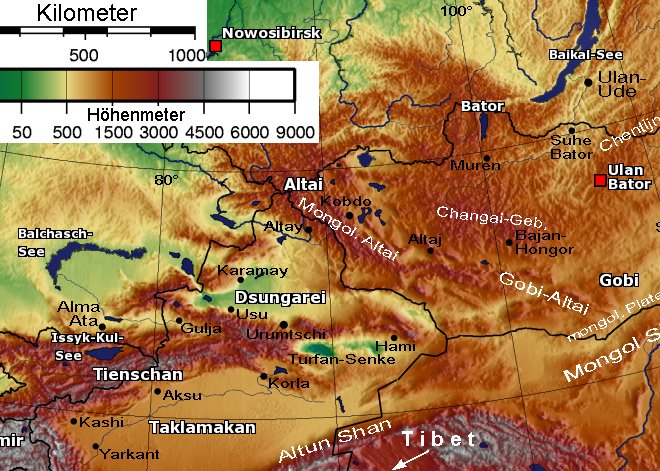
English: * Description: Relief Sattelite image Altay mountains and Tian Shan
- Beschreibung: Relief-Satellitenbild Altai-Gebirgsketten und Tienschan
- Quelle: [Bild:Mongolei-SinkiangTxt.png]
- nachbearbeitet 30.5.2005 von Benutzer:Geof (passender Ausschnitt, Maßstabsleiste, Orte etc.)
- Lizenz: gemeinfrei (public domain)
From de:Bild:Altai,Tienschan-Orte.png by de:Benutzer:Geof
Licence: PD-Self
| |
This work has been released into the public domain by its author, Geof, at the English विकिपिडिया project. This applies worldwide. In case this is not legally possible: |
File history
Click on a date/time to view the file as it appeared at that time.
| Date/Time | Thumbnail | Dimensions | छ्य्लामि | Comment | |
|---|---|---|---|---|---|
| current | १५:३६, २६ मार्च २००६ | | ६६० × ४७१ (५६० KB) | Hardscarf | * Description: Relief Sattelite image Altay mountains and Tian Shan * Beschreibung: Relief-Satellitenbild Altai-Gebirgsketten und Tienschan * Quelle: [Bild:Mongolei-SinkiangTxt.png] * nachbearbeitet 30.5.2005 von Benutzer:Geof (passender Ausschnitt, Maß |
File usage
The following page uses this file:
Global file usage
The following other wikis use this file:
- Usage on af.wikipedia.org
- Usage on an.wikipedia.org
- Usage on ar.wikipedia.org
- Usage on arz.wikipedia.org
- Usage on ast.wikipedia.org
- Usage on be-tarask.wikipedia.org
- Usage on be.wikipedia.org
- Usage on bn.wikipedia.org
- Usage on bs.wikipedia.org
- Usage on ca.wikipedia.org
- Usage on ceb.wikipedia.org
- Usage on cs.wikipedia.org
- Usage on cy.wikipedia.org
- Usage on da.wikipedia.org
- Usage on de.wikipedia.org
- Usage on el.wikipedia.org
- Usage on en.wikipedia.org
- Tarim Basin
- Dzungaria
- Talk:History of the administrative divisions of China before 1912
- Altyn-Tagh
- User:Mattisse/Work
- Dzungarian Gate
- South Central Siberia
- Xinjiang
- User:Dzung01
- Altishahr
- Dzungar conquest of Altishahr
- Wikipedia:Graphics Lab/Map workshop/Archive/Dec 2015
- User:Hidayetullah/sandbox
- Talk:History of Xinjiang/Archive 1
- Usage on eo.wikipedia.org
- Usage on es.wikipedia.org
View more global usage of this file.